
Cockcrow Green Bridge: Surrey's 30-metre wildlife crossing over the A3
Cockcrow Green Bridge in Surrey is a 30-metre heathland crossing over the A3. What it reconnects, why it matters and what evidence needs to follow.
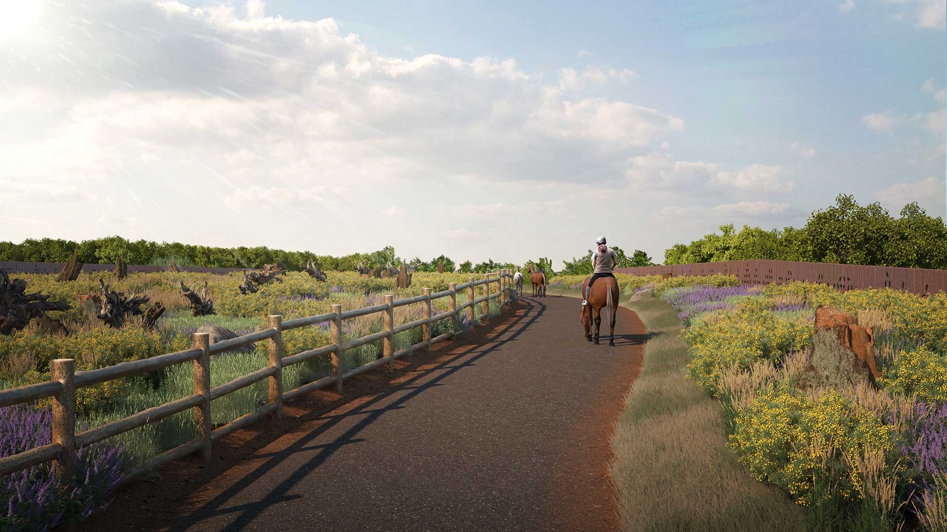
Cockcrow Green Bridge now carries heathland over the A3 in Surrey, reconnecting Ockham and Wisley Commons with a 30-metre planted crossing. The structure is finished. The slower question is whether it becomes a route that wildlife actually uses.
From a car on the A3, the road at the M25 Junction 10 scheme is a fast route through Surrey. On the new bridge above it, the intention is the opposite: heathland can continue across a barrier that had divided two areas of the Thames Basin Heaths.
Cockcrow Green Bridge was completed in March 2026. It joins Ockham and Wisley Commons, which the government says were previously separated by the road. At 30 metres wide and 68 metres long, it is large enough to carry a planted strip of lowland heath rather than a narrow pedestrian overpass with a few shrubs at the edge.
That distinction is the point. A road can divide a landscape for decades without looking unusual from the driver's seat. The new crossing makes that division visible, then gives the habitat a way over it.
A crossing built into a road scheme
The bridge is part of National Highways' wider M25 Junction 10 improvement project. The Government Estate Nature Plan describes it as part of a 3.8-kilometre corridor of restored lowland heathland across the scheme, while National Highways sets out the bridge's dimensions and planned heathland planting.
The two commons sit within the internationally designated Thames Basin Heaths. That designation reflects the importance of the area for heathland wildlife, but a designation on a map does not remove the physical effect of a busy road cutting through it. The bridge is a piece of infrastructure built to reduce that gap.
National Highways has said the wider local area lost around 85% of its ancient heathland over the past 200 years. A single crossing cannot reverse that history. It can reconnect one broken part of the remaining landscape and make restoration less dependent on animals attempting to cross traffic or staying on one side of it.
That is why position matters as much as planting. A strip of vegetation beside a road may improve one verge. A bridge creates a continuous route across a specific obstruction. Its value will depend on how well it joins habitat beyond the concrete, not simply on how green it looks from the carriageway.
Heathland over traffic
The planting is designed around heathland rather than ornamental landscaping. National Highways describes heather and shrubs on the crossing, with sand lizards, silver-studded butterflies and heath tiger beetles among the species the scheme is intended to support.
That gives the bridge a more demanding job than simply looking green from above. Heathland has to establish in shallow, exposed conditions. Plants need to survive, the surface needs to remain suitable and the route needs to sit within usable habitat on both sides of the road. A bridge covered in failed planting would still connect two points on a map, but it would not offer much of a corridor.
The England wildlife-rich habitat progress check looks at the national measurement problem: hectares can record action, but connections, condition and habitat variety determine what those hectares do. Cockcrow is the physical version of that question in one small, visible place.
Two ways across
The bridge is also designed for people. National Highways says a four-metre track will give pedestrians, cyclists and horse riders a route over the A3. That is useful in its own right, particularly where a trunk road can make a short local journey feel impossible or unsafe.
The public-place side of this work is different from the ecological test. The British Uplift explains what the new crossing means for walking, cycling, riding and clear route information around Surrey's commons.
Shared access does not turn the structure into an ordinary leisure path. The route and the planted heathland have to work alongside each other, with design and management that avoid treating wildlife as decoration around a transport link. It is a practical reminder that reconnecting a place can involve people and wildlife without making their needs identical.
The England active-travel progress article follows a broader version of the same access question: crossings and continuous routes matter because a good stretch of path is less useful when a major road remains the break in the journey.
What is built, and what still has to be seen
| What is in place | What later evidence needs to show |
|---|---|
| A 30-metre-wide, 68-metre-long bridge over the A3, completed in March 2026. | Whether the planted surface establishes as functioning heathland rather than only a new structure with vegetation. |
| A connection between Ockham and Wisley Commons within a wider restored-heathland corridor. | Whether target species and other wildlife move between the two sides of the road. |
| Planting intended to support heathland species including sand lizards and silver-studded butterflies. | Whether the local habitat supports those species through the seasons and over several years. |
| A shared route for walking, cycling and riding. | Whether access remains safe and usable while the adjoining habitat is protected and maintained. |
The table is not a reason to discount the opening. The bridge exists, the road is no longer an unbroken barrier at this point and the route is a practical change for the two commons. It is simply too early to treat that construction milestone as proof of a recovered population, lower road mortality or a mature ecological corridor.
The evidence arrives after opening
For the first years, the most useful checks will be ordinary and specific: how the heathland planting survives, whether invasive species or wear affect the surface, and whether the conditions on the bridge still match the habitat on either side. National Highways says habitat management and monitoring around the wider project are planned for up to 25 years.
Later evidence could include camera monitoring, ecological surveys, track or invertebrate records, and road-safety data where a robust before-and-after comparison is possible. Each method answers a different question. An animal recorded on the bridge is evidence of use, not necessarily of population recovery. A healthier local population would need a longer record of breeding, survival and habitat condition.
The Dartford warbler recovery shows why connected heath matters. The latest UK population estimate has reached 4,100 pairs, with some of the strongest counts on reserves where fragmented heathland has been restored and joined. The England species recovery programme funds the wider project pipeline, but the field evidence remains the test after work begins.
A bridge that has to grow into its job
The A3 still carries traffic at speed. Above it, a planted crossing has now closed one gap between the commons. That is a real change in the landscape, not a promise on a drawing.
The good outcome is not guaranteed by the deck alone. Heathland has to take hold, animals have to find the route and the connection has to remain part of a larger cared-for landscape. The bridge is finished. The corridor has to grow into its job.
Useful source links
- National Highways: M25 Junction 10 and the environment
- National Highways: pedestrian, cycle and horse-riding routes at Junction 10
- National Highways: M25 Junction 10 project page
- GOV.UK: Government Estate Nature Plan announcement
- Feature image: National Highways Cockcrow Heathland Bridge photograph, Crown copyright, reused under the Open Government Licence
Data checked
This article was checked on 10 July 2026 against National Highways' M25 Junction 10 environment, access and project pages and the Government Estate Nature Plan announcement. Review after National Highways, Surrey Wildlife Trust or another primary monitoring source publishes evidence on habitat establishment, target-species movement, road mortality or shared-route use.
Information only
This article is for general information. It is not ecology, land-management, transport, route-access, planning or safety advice. Check current official guidance before visiting the area or making a decision that depends on access, habitat management or road conditions.